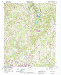
1969 Map of Belews Creek
USGS Topo · Published 1994About this map
The waters of Belews Lake dominate the northern terrain along the border of Forsyth and Guilford counties, representing a significant landscape shift recorded during the 1960s. The region is defined by its rural density, marked by numerous community churches such as Rock Hill Ch, Antioch Ch, and Oak Spring Ch that anchor small settlements like Belews Creek and Crims Crossroads. Transportation routes like Old Flatrock Road and Stafford Mill Road connect these crossroads, while the industrial and agricultural character is noted by a Quarry and the Sellers Landing Strip.
Find a feature on this map
40 named features on this map. Tap any name to fly to it.
Don’t see what you’re looking for? This feature index may not catch every label — zoom into the map to look around manually.
Map Details
Editions of this 1969 Belews Creek Map

Other maps of this area

1950 · Winston-Salem East
USGS Topo · 1:24,000

1951 · Winston-Salem East
USGS Topo · 1:24,000

1951 · Guilford
USGS Topo · 1:24,000

1951 · Walkertown
USGS Topo · 1:24,000

1953 · Winston-Salem
USGS Topo · 1:250,000

1953 · Greensboro
USGS Topo · 1:250,000

1954 · Greensboro
USGS Topo · 1:250,000

1955 · Winston-Salem
USGS Topo · 1:250,000

1962 · Winston-Salem
USGS Topo · 1:250,000

1962 · Greensboro
USGS Topo · 1:250,000