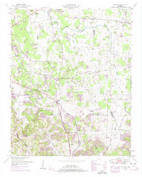
1949 Map of Belfast
USGS Topo · Published 1975About this map
Belfast serves as a central hub in this Tennessee landscape, where the Louisville and Nashville RR cuts through the terrain near Blackwell Crossing. The map reveals a post-war rural society defined by a dense network of country churches and family burial grounds, such as Rocky Point Church and Adams Cem. To the north, the settlement of Farmington is marked by the Confederate Memorial Park, reflecting the deep historical roots of the region. The topography transitions from the agricultural flats near East Rock Creek and Mud Creek into the more varied elevations of Grandview Ridge and Davidson Hill. Educational and spiritual life is anchored by landmarks like the Cedar Grove School and Head Springs Church, while natural features like Blowing Cave and Twitty Spring punctuate the hollows of Liberty Valley.
Find a feature on this map
45 named features on this map. Tap any name to fly to it.
Don’t see what you’re looking for? This feature index may not catch every label — zoom into the map to look around manually.
Map Details
Editions of this 1949 Belfast Map
2 editions found
Other maps of this area

1936 · Farmington
USGS Topo · 1:24,000

1936 · Belfast
USGS Topo · 1:24,000

1936 · Cornersville
USGS Topo · 1:24,000

1936 · Lewisburg
USGS Topo · 1:24,000

1936 · Belleville
USGS Topo · 1:24,000

1936 · Verona
USGS Topo · 1:24,000

1936 · Petersburg
USGS Topo · 1:24,000

1936 · Unionville
USGS Topo · 1:24,000

1936 · Bedford
USGS Topo · 1:24,000

1944 · Shelbyville
USGS Topo · 1:100,000