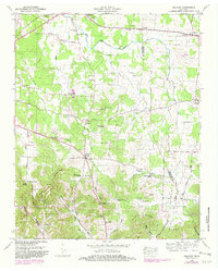
1949 Map of Belfast
USGS Topo · Published 1982About this map
Belfast sits at the intersection of local history and rugged geography in southern Tennessee, where the Marshall Co and Bedford Co line cuts through a landscape of ridges and hollows. The area's communal identity is centered around various rural institutions, including the Confederate Memorial Park near Farmington and several local congregations such as Head Springs Church and Rocky Point Church. The topography is defined by the prominent Elk Ridge and Poplar Ridge, which are separated by Bagley Gap, creating a natural corridor that has influenced settlement patterns for generations.
Find a feature on this map
75 named features on this map. Tap any name to fly to it.
Don’t see what you’re looking for? This feature index may not catch every label — zoom into the map to look around manually.
Map Details
Editions of this 1949 Belfast Map
2 editions found
Other maps of this area

1936 · Farmington
USGS Topo · 1:24,000

1936 · Belfast
USGS Topo · 1:24,000

1936 · Cornersville
USGS Topo · 1:24,000

1936 · Lewisburg
USGS Topo · 1:24,000

1936 · Belleville
USGS Topo · 1:24,000

1936 · Verona
USGS Topo · 1:24,000

1936 · Petersburg
USGS Topo · 1:24,000

1936 · Unionville
USGS Topo · 1:24,000

1936 · Bedford
USGS Topo · 1:24,000

1944 · Shelbyville
USGS Topo · 1:100,000