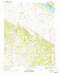
1970 Map of Belgique
USGS Topo · Published 1972About this map
Mississippi River bottomlands and the floodplain of Bois Brule define the landscape of this 1970 survey along the Missouri-Illinois border. The river's influence is evident in the engineered Levee system and the presence of riverine features like Crains Island and Puckett Island, separated from the mainland by Puckett Chute. On the higher ground southwest of the alluvial plain, the map captures a network of rural settlements and family-named landmarks.
Find a feature on this map
30 named features on this map. Tap any name to fly to it.
Don’t see what you’re looking for? This feature index may not catch every label — zoom into the map to look around manually.
Map Details
Editions of this 1970 Belgique Map
This is the sole edition of this map. No revisions or reprints were ever made.
Other maps of this area

1915 · Chester
USGS Topo · 1:62,500

1916 · Campbell Hill
USGS Topo · 1:62,500

1918 · Altenburg
USGS Topo · 1:62,500

1918 · Campbell Hill
USGS Topo · 1:62,500

1923 · Perryville
USGS Topo · 1:62,500

1924 · Perryville
USGS Topo · 1:62,500

1925 · Altenburg
USGS Topo · 1:62,500

1947 · Chester
USGS Topo · 1:62,500

1947 · Crosstown
USGS Topo · 1:24,000

1947 · Altenburg
USGS Topo · 1:62,500