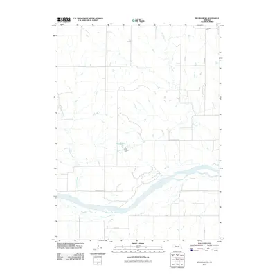
2011 Map of Belgrade SW
USGS Topo · Published 2011About this map
The Loup River dominates this section of the Nebraska plains, carving a broad path through the landscape while supported by a network of drainage including Horse Creek, Cottonwood Creek, and Elk Creek. At the northern edge of the map, the small settlement of North Star sits along N Star Rd, serving as a focal point for the surrounding agricultural district. The influence of local land management is evident at the Davis Brothers Reservoir, created by the Davis Brothers Dam. This infrastructure, combined with the grid of section roads like Pleasant Valley Rd and Elk Creek Rd, illustrates the systematic organization of the rural Nance County countryside. The map reveals the relationship between water resources and transport, where roads often run parallel to or intersect these vital waterways.
Find a feature on this map
17 named features on this map. Tap any name to fly to it.
Don’t see what you’re looking for? This feature index may not catch every label — zoom into the map to look around manually.
Map Details
Editions of this 2011 Belgrade SW Map
This is the sole edition of this map. No revisions or reprints were ever made.
Other maps of this area

1899 · St. Paul
USGS Topo · 1:125,000

1954 · Wolbach NE
USGS Topo · 1:24,000

1954 · Belgrade
USGS Topo · 1:24,000

1954 · Belgrade NW
USGS Topo · 1:24,000

1955 · Belgrade SW
USGS Topo · 1:24,000

1955 · Broken Bow
USGS Topo · 1:250,000

1955 · Belgrade SE
USGS Topo · 1:24,000

1955 · Cushing
USGS Topo · 1:24,000

1956 · Broken Bow
USGS Topo · 1:250,000
1961 · Palmer
USGS Topo · 1:24,000