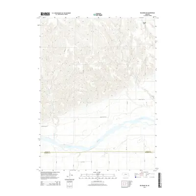
2014 Map of Belgrade SW
USGS Topo · Published 2014About this map
North Star anchors the northern high ground of this Nebraska landscape, where the terrain transitions from upland ridges down toward the broad valley of the Loup River. This 2014 survey documents a predominantly agricultural region defined by its water management and drainage patterns, including the Davis Brothers Reservoir and several major tributaries such as Cottonwood Cr and Horse Cr. The southern portion of the map is marked by the straight east-west boundary between Nance Co and Merrick Co, which runs just north of the river's meandering course. The road network, consisting of named routes like Pleasant Valley Rd and Elk Creek Rd, follows a strict grid that illustrates the persistence of the Public Land Survey System in organizing the rural Nebraska prairie more than a century after its initial settlement.
Find a feature on this map
22 named features on this map. Tap any name to fly to it.
Don’t see what you’re looking for? This feature index may not catch every label — zoom into the map to look around manually.
Map Details
Editions of this 2014 Belgrade SW Map
This is the sole edition of this map. No revisions or reprints were ever made.
Other maps of this area

1899 · St. Paul
USGS Topo · 1:125,000

1954 · Wolbach NE
USGS Topo · 1:24,000

1954 · Belgrade
USGS Topo · 1:24,000

1954 · Belgrade NW
USGS Topo · 1:24,000

1955 · Belgrade SW
USGS Topo · 1:24,000

1955 · Broken Bow
USGS Topo · 1:250,000

1955 · Belgrade SE
USGS Topo · 1:24,000

1955 · Cushing
USGS Topo · 1:24,000

1956 · Broken Bow
USGS Topo · 1:250,000
1961 · Palmer
USGS Topo · 1:24,000