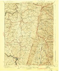
1927 Map of Belington
USGS Topo · Published 1941About this map
Belington serves as the focal point for this survey of north-central West Virginia, where the Tigart River carves through the landscape. The region's early 20th-century character is defined by a dense network of country schools and small settlements like Nestorville and Kalamazoo. The industrial and agricultural foundations of the era are evident in features such as Vannoys Mill and Valley Furnace, while the Baltimore and Ohio Railroad and the Western Maryland Railroad provide the vital transport links along the river valleys.
Find a feature on this map
110 named features on this map. Tap any name to fly to it.
Don’t see what you’re looking for? This feature index may not catch every label — zoom into the map to look around manually.
Map Details
Editions of this 1927 Belington Map
2 editions found

Other maps of this area

1886 · St. George
USGS Topo · 1:125,000

1889 · Beverly
USGS Topo · 1:125,000

1891 · St. George
USGS Topo · 1:125,000

1892 · Beverly
USGS Topo · 1:125,000

1893 · Buckhannon
USGS Topo · 1:125,000

1896 · Buckhannon
USGS Topo · 1:125,000

1897 · Buckhannon
USGS Topo · 1:125,000

1902 · Fairmont
USGS Topo · 1:62,500

1904 · Philippi
USGS Topo · 1:62,500

1907 · Thornton
USGS Topo · 1:62,500