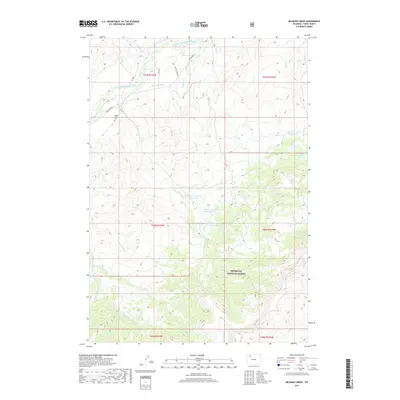
2017 Map of Belknap Creek
USGS Topo · Published 2017About this map
Wapiti Valley Cem sits near the northern boundary of this high-elevation landscape, where the waters of the South Fork Shoshone River flow through the valley. This 2017 survey reveals a complex network of water management and natural drainages within the Shoshone National Forest, characterized by numerous high-country reservoirs such as Belknap Cr Number 1 Reservoir and Swan Cr Number 2 Reservoir. These engineered water bodies, connected by names like the Lakeview Ditch, suggest a landscape historically modified for irrigation or livestock despite the elevation. The terrain is deeply incised by multiple forks of Rock Cr, including the Middle Fork Rock Cr and E Fork Rock Cr, alongside other prominent drainages like N Meeteetse Cr and Timber Cr. These natural features, combined with high lakes such as Irma Lake and Lily Lake, define a remote territory governed by seasonal water flow and federal forest management.
Find a feature on this map
29 named features on this map. Tap any name to fly to it.
Don’t see what you’re looking for? This feature index may not catch every label — zoom into the map to look around manually.
Map Details
Editions of this 2017 Belknap Creek Map
This is the sole edition of this map. No revisions or reprints were ever made.
Other maps of this area

1955 · Cody
USGS Topo · 1:250,000

1957 · Wapiti
USGS Topo · 1:62,500

1957 · Devils Tooth
USGS Topo · 1:62,500

1957 · Irish Rock
USGS Topo · 1:62,500

1957 · Sunshine Reservoir
USGS Topo · 1:62,500

1958 · Cody
USGS Topo · 1:250,000

1962 · Cody
USGS Topo · 1:250,000

1980 · Carter Mountain
USGS Topo · 1:100,000
1987 · Devils Tooth
USGS Topo · 1:24,000
1987 · Irma Flats
USGS Topo · 1:24,000