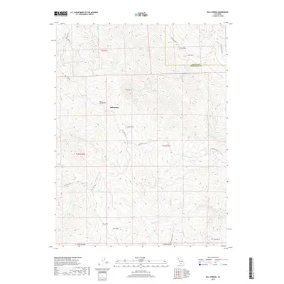
2018 Map of Bell Springs
USGS Topo · Published 2018About this map
Bell Springs stands as the primary namesake settlement in this section of the northern Inner Coast Ranges, situated along the historic route of Bell Springs Rd. The landscape is defined by its dramatic vertical relief, bridging the border between Trinity and Mendocino counties. To the south, Mail Ridge provides a high-elevation spine above the deeply incised drainages of Blue Rock Cr and Cruso Cabin Cr. Distinctive geologic landmarks such as White Slide, Camel Rock, and Blue Rock dot the steep slopes, while Island Mtn dominates the northeastern corner. The mapping shows a remote network of ranch and access roads, including Lundblade Ranch Rd and Red Mountain Rd, which navigate the complex topography of the Bell Springs Mtn area, reflecting the region's enduring character as a sparsely populated frontier of rugged ranch land and watershed.
Find a feature on this map
32 named features on this map. Tap any name to fly to it.
Don’t see what you’re looking for? This feature index may not catch every label — zoom into the map to look around manually.
Map Details
Editions of this 2018 Bell Springs Map
This is the sole edition of this map. No revisions or reprints were ever made.
Other maps of this area

1920 · Cummings
USGS Topo · 1:62,500

1920 · Covelo
USGS Topo · 1:62,500

1920 · Harris
USGS Topo · 1:62,500

1921 · Hoaglin
USGS Topo · 1:62,500

1922 · Island Mountain
USGS Topo · 1:62,500

1931 · Hoaglin
USGS Topo · 1:96,000

1935 · Hoaglin
USGS Topo · 1:125,000

1949 · Alderpoint
USGS Topo · 1:62,500

1951 · Alderpoint
USGS Topo · 1:62,500

1952 · Spyrock
USGS Topo · 1:62,500