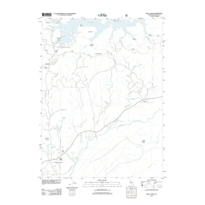
2012 Map of Bella Vista
USGS Topo · Published 2012About this map
Shasta Lake dominates the northern reaches of this region, its irregular shoreline forming Silverthorn Bay and providing a backdrop for the Jones Valley Marina. This landscape is defined by the transition from the high elevations of Backbone Ridge down toward the alluvial Swede Creek Plains in the southeast. Settlement patterns are concentrated along the winding corridors of Little Cow Creek and Dry Creek, where small communities such as Bella Vista and Frazier Corners serve as local hubs.
Find a feature on this map
73 named features on this map. Tap any name to fly to it.
Don’t see what you’re looking for? This feature index may not catch every label — zoom into the map to look around manually.
Map Details
Editions of this 2012 Bella Vista Map
This is the sole edition of this map. No revisions or reprints were ever made.
Other maps of this area

1890 · Red Bluff
USGS Topo · 1:250,000

1894 · Red Bluff
USGS Topo · 1:250,000

1901 · Redding
USGS Topo · 1:125,000

1944 · Redding
USGS Topo · 1:62,500

1946 · Lamoine
USGS Topo · 1:62,500

1946 · Redding
USGS Topo · 1:62,500

1949 · Bollibokka Mtn
USGS Topo · 1:62,500

1953 · Millville
USGS Topo · 1:62,500
1957 · Enterprise
USGS Topo · 1:24,000
1957 · Project City
USGS Topo · 1:24,000