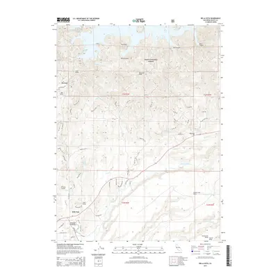
2015 Map of Bella Vista
USGS Topo · Published 2015About this map
Bella Vista and Frazier Corners anchor the southern portion of this landscape where the Sacramento Valley begins its ascent into the northern highlands. The transition from the valley floor to the foothills is marked by a complex network of drainages, including Little Cow Creek, French Cr, and Swede Cr. This 2015 survey shows a rural-residential pattern in the south, while the northern half is dominated by the rugged slopes of the Shasta National Forest. Dramatic elevation changes are evident along Backbone Ridge and within several deep incisions such as Stinking Canyon and Wildcat Canyon. The map records several small water bodies, including Mirror Lake and Elks Lake, alongside the extensive reach of the Pit River Arm in the northeast. This topography illustrates the intersection of agricultural plains, forest management areas, and the developing communities of eastern Shasta County.
Find a feature on this map
72 named features on this map. Tap any name to fly to it.
Don’t see what you’re looking for? This feature index may not catch every label — zoom into the map to look around manually.
Map Details
Editions of this 2015 Bella Vista Map
This is the sole edition of this map. No revisions or reprints were ever made.
Other maps of this area

1890 · Red Bluff
USGS Topo · 1:250,000

1894 · Red Bluff
USGS Topo · 1:250,000

1901 · Redding
USGS Topo · 1:125,000

1944 · Redding
USGS Topo · 1:62,500

1946 · Lamoine
USGS Topo · 1:62,500

1946 · Redding
USGS Topo · 1:62,500

1949 · Bollibokka Mtn
USGS Topo · 1:62,500

1953 · Millville
USGS Topo · 1:62,500
1957 · Enterprise
USGS Topo · 1:24,000
1957 · Project City
USGS Topo · 1:24,000