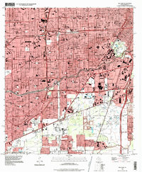
1995 Map of Bellaire
USGS Topo · Published 1999About this map
The sprawling footprint of the Texas Medical Center and Rice University anchors the eastern side of this Harris County survey, showcasing a massive complex of institutions including Methodist Hospital, St Lukes Hosp, and Ben Taub Hospital. To the south, the iconic entertainment district is fully realized with the Astrodome, Astrohall, and the Astroworld theme park, representing a peak era of Houston's mid-century urban development.
Find a feature on this map
71 named features on this map. Tap any name to fly to it.
Don’t see what you’re looking for? This feature index may not catch every label — zoom into the map to look around manually.
Map Details
Editions of this 1995 Bellaire Map
This is the sole edition of this map. No revisions or reprints were ever made.
Other maps of this area

1915 · Bellaire
USGS Topo · 1:24,000

1915 · Park Place
USGS Topo · 1:24,000

1915 · Houston Heights
USGS Topo · 1:24,000

1915 · Alief
USGS Topo · 1:24,000

1915 · Hillendahl
USGS Topo · 1:24,000

1916 · Settegast
USGS Topo · 1:24,000

1918 · Hillendahl
USGS Topo · 1:31,680

1920 · Mykawa
USGS Topo · 1:31,680

1920 · Almeda
USGS Topo · 1:31,680

1921 · Bellaire
USGS Topo · 1:31,680