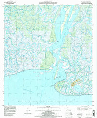
1994 Map of Belle Isle
USGS Topo · Published 1998About this map
Belle Isle rises as a prominent landmark amidst the intricate labyrinth of bayous and marshlands along the Louisiana coast in St. Mary Parish. This mid-1990s landscape is defined by the heavy presence of the Belle Isle Oil and Gas Field, showing a network of pipelines and canals that cut through the wetlands to facilitate energy extraction. The intersection of industry and preservation is evident as the Atchafalaya Delta State Wildlife Management Area covers a significant portion of the Atchafalaya Bay coastline.
Find a feature on this map
39 named features on this map. Tap any name to fly to it.
Don’t see what you’re looking for? This feature index may not catch every label — zoom into the map to look around manually.
Map Details
Editions of this 1994 Belle Isle Map
This is the sole edition of this map. No revisions or reprints were ever made.
Other maps of this area

1935 · Belle Isle
USGS Topo · 1:31,680

1937 · Bayou Sale
USGS Topo · 1:62,500

1941 · Belle Isle
USGS Topo · 1:62,500

1945 · New Orleans
USGS Topo · 1:250,000

1954 · Belle Isle
USGS Topo · 1:62,500

1957 · Bayou Sale
USGS Topo · 1:62,500

1957 · Point Au Fer
USGS Topo · 1:62,500

1963 · New Orleans
USGS Topo · 1:250,000

1966 · New Orleans
USGS Topo · 1:250,000
1966 · Lake Salve
USGS Topo · 1:24,000