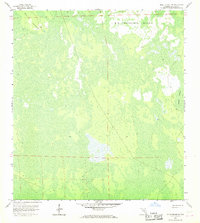
1958 Map of Belle Meade NE
USGS Topo · Published 1968About this map
Big Corkscrew Island and the surrounding wetlands of Collier County dominate this mid-century landscape. Based on aerial photography from the early 1950s and planetable surveys from 1958, the map illustrates an environment defined by seasonal water and island-like hammocks. The presence of a lone Camp and the naming of Stumpy Strand and Curry Island point to the area's use by hunters or early explorers before significant drainage and development reached this section of the Florida interior. These features, along with several benchmark elevations like BM 14, provide a rare look at the original topographical structure of the Big Cypress region during a period when many land lines remained unsurveyed or were only established by private survey.
Find a feature on this map
7 named features on this map. Tap any name to fly to it.
Don’t see what you’re looking for? This feature index may not catch every label — zoom into the map to look around manually.
Map Details
Editions of this 1958 Belle Meade NE Map
4 editions found
Other maps of this area

1956 · West Palm Beach
USGS Topo · 1:250,000

1957 · West Palm Beach
USGS Topo · 1:250,000

1958 · West Palm Beach
USGS Topo · 1:250,000

1958 · Corkscrew SE
USGS Topo · 1:24,000

1958 · Belle Meade
USGS Topo · 1:24,000

1958 · Catherine Island
USGS Topo · 1:24,000

1958 · Belle Meade NE
USGS Topo · 1:24,000

1958 · Belle Meade NW
USGS Topo · 1:24,000

1958 · Immokalee SW
USGS Topo · 1:24,000

1958 · Corkscrew SW
USGS Topo · 1:24,000