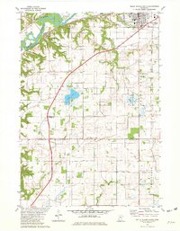
1981 Map of Belle Plaine South
USGS Topo · Published 1982About this map
The Minnesota River valley shapes the northwestern portion of this area, where the Chicago and North Western rail line follows the riverbank through the small settlement of Blakeley. Further east, the town of Belle Plaine sits on the higher terrace, showing a concentrated grid of streets anchored by its High Sch and religious sites like Sacred Heart Cem. The surrounding townships of Blakeley, Belle Plaine, Tyrone, and Derry Nane reveal a landscape transitioning from river bluffs to an agricultural plain dissected by Judicial Ditch No 2. Local history is preserved in several rural burial grounds, including Schlegel Cem and the Church of the Redeemer Cem. Drainage and water management are prominent themes, visible in the extensive network of ditches and the Mahoney State Wildlife Management Area.
Find a feature on this map
29 named features on this map. Tap any name to fly to it.
Don’t see what you’re looking for? This feature index may not catch every label — zoom into the map to look around manually.
Map Details
Editions of this 1981 Belle Plaine South Map
This is the sole edition of this map. No revisions or reprints were ever made.
Other maps of this area

1953 · Saint Paul
USGS Topo · 1:250,000

1957 · Belle Plaine
USGS Topo · 1:62,500

1957 · New Prague
USGS Topo · 1:62,500

1959 · Saint Paul
USGS Topo · 1:250,000

1965 · Le Sueur
USGS Topo · 1:24,000

1965 · St Thomas
USGS Topo · 1:24,000

1966 · Le Center
USGS Topo · 1:24,000
1981 · Jordan West
USGS Topo · 1:24,000
1981 · Hamburg
USGS Topo · 1:24,000
1981 · Union Hill
USGS Topo · 1:24,000