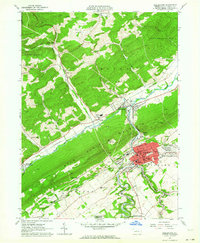
1962 Map of Bellefonte
USGS Topo · Published 1964About this map
Bellefonte serves as the dense cultural and institutional hub of this Central Pennsylvania landscape, characterized by its concentrated street grid featuring Linn St, High St, and Bishop St. As the county seat, the borough contains vital civic landmarks including the County Hospital, County Home, and the Armory. The surrounding terrain is dominated by the massive ridge of Bald Eagle Mountain, which separates the industrial and residential activity along Pennsylvania Creek from the more dispersed settlements of Boggs and Union townships.
Find a feature on this map
75 named features on this map. Tap any name to fly to it.
Don’t see what you’re looking for? This feature index may not catch every label — zoom into the map to look around manually.
Map Details
Editions of this 1962 Bellefonte Map
2 editions found
Other maps of this area

1908 · Bellefonte
USGS Topo · 1:62,500

1909 · Bellefonte
USGS Topo · 1:62,500

1921 · Howard
USGS Topo · 1:48,000

1923 · Howard
USGS Topo · 1:62,500

1924 · Centre Hall
USGS Topo · 1:62,500

1928 · Snow Shoe
USGS Topo · 1:48,000

1929 · Centre Hall
USGS Topo · 1:62,500

1931 · Show Shoe
USGS Topo · 1:62,500

1943 · Lewistown
USGS Topo · 1:125,000

1950 · Harrisburg
USGS Topo · 1:250,000