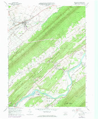
1966 Map of Belleville
USGS Topo · Published 1972About this map
Belleville sits at the northern end of this survey, serving as a hub within the Big Valley where Kishacoquillas Creek and Little Kishacoquillas Creek converge. The landscape is defined by the heavy parallel ridges of the Appalachian Mountains, with Jacks Mountain and Blue Mountain creating deep, isolated valleys. The southern portion of the map centers on the winding Juniata River, a critical transportation corridor occupied by the Penn Central railroad and a series of riverfront settlements including McVeytown, Lockport, and Anderson.
Find a feature on this map
63 named features on this map. Tap any name to fly to it.
Don’t see what you’re looking for? This feature index may not catch every label — zoom into the map to look around manually.
Map Details
Editions of this 1966 Belleville Map
2 editions found
Other maps of this area

1919 · Mattawana
USGS Topo · 1:62,500

1919 · Menno
USGS Topo · 1:62,500

1922 · Mt Union
USGS Topo · 1:48,000

1924 · Mt. Union
USGS Topo · 1:62,500

1924 · Lewistown
USGS Topo · 1:62,500

1927 · Lewisburg
USGS Topo · 1:62,500

1935 · Allensville
USGS Topo · 1:62,500

1936 · East Waterford
USGS Topo · 1:48,000

1938 · Allensville
USGS Topo · 1:62,500

1941 · East Waterford
USGS Topo · 1:62,500