
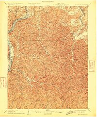
1906 Map of Belleville
USGS Topo · Published 1906About this map
The Ohio River forms a jagged western border for this 1903 survey, separating West Virginia from Ohio. Deeply dissected hills define the interior, where small settlements like Wadeville and Rockport are linked by a dense network of winding runs and creeks. The Baltimore and Ohio RR tracks follow the river's edge, connecting the riverfront landing at Belleville with industrial hubs to the north. In the northeast corner, the Little Kanawha River carves a path through the landscape near Mineral Wells. This era shows a transition where river commerce and new rail lines dictated the growth of rural communities. Local history researchers can trace old family-named landmarks like Walkers Crossing or Topins Grove, while the river islands—including Mustapha and Meldahl—provide a look at the natural waterway before modern navigational adjustments.
Find a feature on this map
122 named features on this map. Tap any name to fly to it.
Don’t see what you’re looking for? This feature index may not catch every label — zoom into the map to look around manually.
Map Details
Editions of this 1906 Belleville Map
2 editions found
Other maps of this area

1902 · Parkersburg
USGS Topo · 1:62,500

1904 · Parkersburg
USGS Topo · 1:62,500

1904 · Marietta
USGS Topo · 1:62,500

1904 · Chesterhill
USGS Topo · 1:62,500

1906 · Elizabeth
USGS Topo · 1:62,500

1906 · Chesterhill
USGS Topo · 1:62,500

1907 · Spencer
USGS Topo · 1:62,500

1907 · Keno
USGS Topo · 1:62,500

1907 · Ripley
USGS Topo · 1:62,500

1908 · Ravenswood
USGS Topo · 1:62,500