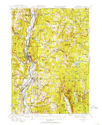
1927 Map of Bellows Falls
USGS Topo · Published 1957About this map
Bellows Falls serves as a primary hub of activity along the Connecticut River in this 1920s survey, where the river's path defines the boundary between Vermont and New Hampshire. The Boston and Maine Railroad corridors trace the valley floor, supporting a network of industrial and residential pockets including Gageville and North Walpole. Further inland, the landscape transitions into a series of upland farming and milling communities such as Alstead and South Acworth. The presence of specialized institutions like the Kurn Hattin Home near Westminster and the Wellman Pd Mica Mine Sch highlights the social and economic diversity of the region. Local history is deeply embedded in the terrain names, from the granite heights of Fall Mountain and Mt Kilburn to the scattered district schools like Pine Bank Sch and Hemlock Sch that once anchored these rural hillsides.
Find a feature on this map
140 named features on this map. Tap any name to fly to it.
Don’t see what you’re looking for? This feature index may not catch every label — zoom into the map to look around manually.
Map Details
Editions of this 1927 Bellows Falls Map
4 editions found
Other maps of this area

1891 · Brattleboro
USGS Topo · 1:62,500

1893 · Brattleboro
USGS Topo · 1:62,500

1898 · Monadnock
USGS Topo · 1:62,500

1898 · Keene
USGS Topo · 1:62,500

1902 · Sunapee
USGS Topo · 1:62,500

1905 · Sunapee
USGS Topo · 1:62,500

1907 · Sunapee
USGS Topo · 1:62,500

1926 · Claremont
USGS Topo · 1:62,500

1927 · Bellows Falls
USGS Topo · 1:48,000

1928 · Ludlow
USGS Topo · 1:48,000