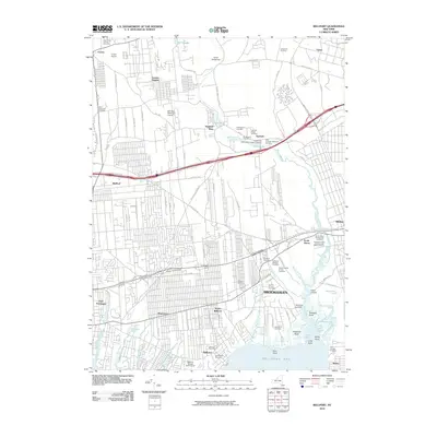
2010 Map of Bellport
USGS Topo · Published 2010About this map
The Carmans River corridor defines the eastern reaches of this Long Island landscape, flowing through Upper Lake and Lower Lake before reaching the marshy inlets of Bellport Bay. The map reveals a dense network of private and community burial grounds, essential for genealogical research, including the Old Bellport Cemetery, the Nathaniel Hawkins Cemetery, and the Samuel Carman and Nathaniel Miller Cemetery. These sites are clustered around established settlements like Yaphank, Brookhaven, and South Haven. Residential expansion and transportation infrastructure, such as the William Floyd Pkwy and Expressway Dr N, are shown alongside local landmarks like Coram Airport and the Bellport Village Golf Course. Coastal features like Fireplace Neck and Squassux Landing highlight the area's maritime geography where Beaverdam Creek and Yaphank Creek meet the bay.
Find a feature on this map
110 named features on this map. Tap any name to fly to it.
Don’t see what you’re looking for? This feature index may not catch every label — zoom into the map to look around manually.
Map Details
Editions of this 2010 Bellport Map
This is the sole edition of this map. No revisions or reprints were ever made.
Other maps of this area

1902 · Setauket
USGS Topo · 1:62,500

1902 · Fire Island
USGS Topo · 1:62,500

1903 · Fire Island
USGS Topo · 1:62,500

1904 · Setauket
USGS Topo · 1:62,500

1904 · Islip
USGS Topo · 1:125,000

1904 · Moriches
USGS Topo · 1:62,500

1919 · Setauket
USGS Topo · 1:62,500

1942 · Islip
USGS Topo · 1:125,000

1947 · Bellport
USGS Topo · 1:24,000

1947 · Howells Point
USGS Topo · 1:24,000