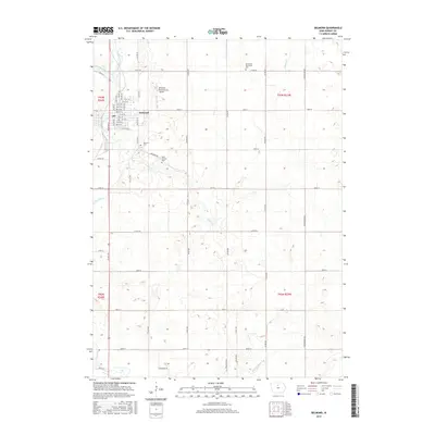
2015 Map of Belmond
USGS Topo · Published 2015About this map
The confluence of the West Branch Iowa River and the East Branch Iowa River defines the landscape of Wright County, where the city of Belmond serves as a local hub. The river system continues south as the main Iowa River, meandering through a terrain marked by glacial depressions and agricultural drainage infrastructure like Ditch Number 146. This 2015 survey details the local street grid, including River Ave N and Main St, while also identifying key community landmarks. Genealogists will find several burial sites recorded, including the Immanuel Reformed Cem to the north, as well as Belmond Cem and Saint Francis Cem situated near the city's southern edge. Transportation and infrastructure are central to the area, evidenced by the Belmond Municipal Airport and a dense network of county roads such as Co RD c20 and Co RD r70 that connect the surrounding farmsteads.
Find a feature on this map
60 named features on this map. Tap any name to fly to it.
Don’t see what you’re looking for? This feature index may not catch every label — zoom into the map to look around manually.
Map Details
Editions of this 2015 Belmond Map
This is the sole edition of this map. No revisions or reprints were ever made.
Other maps of this area

1954 · Waterloo
USGS Topo · 1:250,000

1955 · Waterloo
USGS Topo · 1:250,000

1972 · Cornelia
USGS Topo · 1:24,000

1972 · Alexander
USGS Topo · 1:24,000

1972 · Thornton
USGS Topo · 1:24,000

1972 · Olaf
USGS Topo · 1:24,000

1972 · Belmond
USGS Topo · 1:24,000
1972 · Goodell
USGS Topo · 1:24,000

1978 · Clarion
USGS Topo · 1:24,000

1978 · Dows West
USGS Topo · 1:24,000