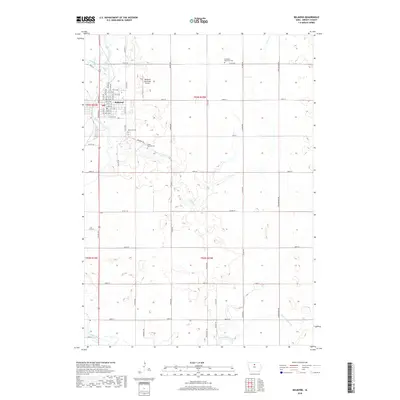
2018 Map of Belmond
USGS Topo · Published 2018About this map
Belmond is the central hub of this Wright County landscape, situated where the West Branch Iowa River and East Branch Iowa River converge to form the main stem of the Iowa River. The town's grid is well-defined by a network of streets including E Main St and several numbered avenues, while the surrounding countryside is characterized by intensive agricultural land management. This management is evidenced by the prominent presence of Ditch Number 146 and other drainage features like Luicks Cr, which serve the low-lying prairie terrain. Genealogists will find several notable burial sites scattered across the township, including Belmond Cem, Saint Francis Cem, and the Immanuel Reformed Cem. The northern outskirts are marked by the Belmond Municipal Airport, highlighting the modern transport infrastructure serving this rural community.
Find a feature on this map
40 named features on this map. Tap any name to fly to it.
Don’t see what you’re looking for? This feature index may not catch every label — zoom into the map to look around manually.
Map Details
Editions of this 2018 Belmond Map
This is the sole edition of this map. No revisions or reprints were ever made.
Other maps of this area

1954 · Waterloo
USGS Topo · 1:250,000

1955 · Waterloo
USGS Topo · 1:250,000

1972 · Cornelia
USGS Topo · 1:24,000

1972 · Alexander
USGS Topo · 1:24,000

1972 · Thornton
USGS Topo · 1:24,000

1972 · Olaf
USGS Topo · 1:24,000

1972 · Belmond
USGS Topo · 1:24,000
1972 · Goodell
USGS Topo · 1:24,000

1978 · Clarion
USGS Topo · 1:24,000

1978 · Dows West
USGS Topo · 1:24,000