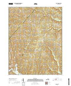
2019 Map of Belmont
USGS Topo · Published 2019About this map
The border of Orange and Spotsylvania counties cuts through a landscape defined by small crossroads and the northern reaches of Lake Anna. This 2019 survey captures the rural character of central Virginia, where historic congregations like Craigs Church Baptist Church and Branch Fork Baptist Church remain focal points for local communities. The terrain is deeply etched by a network of waterways including Plentiful Creek, Catharpin Run, and Terrys Run, which feed into the larger reservoir. Settlement patterns are dispersed across named locales such as Granite Springs, Bells Crossroad, and Paytes. Transportation is marked by small private infrastructure like the Seven Gables Airport and crossings such as Stubbs Bridge and Dillards Bridge, which connect residents across the fingers of the lake and its various coves.
Find a feature on this map
122 named features on this map. Tap any name to fly to it.
Don’t see what you’re looking for? This feature index may not catch every label — zoom into the map to look around manually.
Map Details
Editions of this 2019 Belmont Map
This is the sole edition of this map. No revisions or reprints were ever made.
Other maps of this area

1887 · Spottsylvania
USGS Topo · 1:125,000

1892 · Spottsylvania
USGS Topo · 1:125,000

1942 · Mineral
USGS Topo · 1:31,680

1942 · Lahore
USGS Topo · 1:31,680

1942 · Partlow
USGS Topo · 1:31,680

1942 · Belmont
USGS Topo · 1:31,680

1942 · Contrary Creek
USGS Topo · 1:31,680

1942 · Brokenburg
USGS Topo · 1:31,680

1943 · Chancellorsville
USGS Topo · 1:24,000

1943 · Mine Run
USGS Topo · 1:24,000