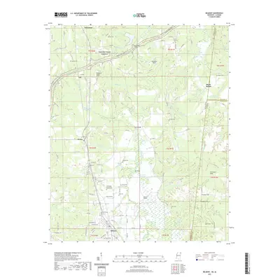
2021 Map of Belmont
USGS Topo · Published 2021About this map
Belmont and Tishomingo anchor the southern and northern reaches of this Mississippi landscape, which is marked by the winding corridor of the Natchez Trace Parkway. The terrain is defined by the Tennessee Valley Divide, where numerous branches and creeks like McDougal Br and Bear Creek carve through the countryside. This area is notably rich in genealogical sites, featuring over a dozen named cemeteries including Highland Cem and the Tishomingo County Rural Burial Ground. The map captures a complex system of water management and transport, with the Bear Creek Floodway and several local crossings such as Southward Bridge and Dennis Bridge. Settlements like Dennis and Freedom Hills are shown alongside distinctive landmarks like Horseshoe Bend and the Chinquapin Ridge, illustrating the rural character of the Mississippi-Alabama borderlands.
Find a feature on this map
73 named features on this map. Tap any name to fly to it.
Don’t see what you’re looking for? This feature index may not catch every label — zoom into the map to look around manually.
Map Details
Editions of this 2021 Belmont Map
This is the sole edition of this map. No revisions or reprints were ever made.
Other maps of this area

1935 · Holcut
USGS Topo · 1:24,000

1935 · Pleasant Site
USGS Topo · 1:24,000

1936 · Belmont
USGS Topo · 1:24,000

1936 · Red Bay
USGS Topo · 1:24,000

1936 · Halltown
USGS Topo · 1:24,000

1936 · Bishop
USGS Topo · 1:24,000

1936 · Tishomingo
USGS Topo · 1:24,000

1950 · Paden
USGS Topo · 1:24,000

1950 · Belmont
USGS Topo · 1:24,000
1950 · Bishop
USGS Topo · 1:24,000