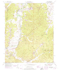
1950 Map of Bishop
USGS Topo · Published 1974About this map
Bear Creek meanders along the Alabama-Mississippi border in this 1950s era survey, defining the rural character of western Colbert County. The landscape is marked by the inundation of the Pickwick Reservoir, where backwaters reach into creek valleys like Cripple Deer Creek. The map documents a community infrastructure rooted in family and faith, with numerous small settlements such as Allsboro, Maud, and Bishop serving as local hubs.
Find a feature on this map
48 named features on this map. Tap any name to fly to it.
Don’t see what you’re looking for? This feature index may not catch every label — zoom into the map to look around manually.
Map Details
Editions of this 1950 Bishop Map
2 editions found
Other maps of this area

1911 · Iuka
USGS Topo · 1:48,000

1914 · Iuka
USGS Topo · 1:62,500

1924 · Gravelly Springs
USGS Topo · 1:48,000

1925 · Barton
USGS Topo · 1:62,500

1926 · Barton
USGS Topo · 1:48,000

1926 · Gravelly Springs
USGS Topo · 1:62,500

1929 · Barton
USGS Topo · 1:62,500

1935 · Cherokee
USGS Topo · 1:24,000

1935 · Iuka
USGS Topo · 1:24,000

1935 · Pleasant Site
USGS Topo · 1:24,000