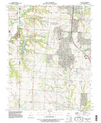
1991 Map of Belton
USGS Topo · Published 1996About this map
The Richards-Gebaur Memorial Airport anchors the landscape of the Missouri-Kansas borderlands in the early 1990s, illustrating the heavy industrial and aviation presence south of Kansas City. This topographic survey captures the meeting of three major counties — Jackson, Cass, and Johnson — as suburban growth begins to encroach on rural terrain. The transition is evident in the dense street grids of Belton compared to the smaller, more isolated settlements of Kenneth, Belvidere, and Jaudon.
Find a feature on this map
27 named features on this map. Tap any name to fly to it.
Don’t see what you’re looking for? This feature index may not catch every label — zoom into the map to look around manually.
Map Details
Editions of this 1991 Belton Map
This is the sole edition of this map. No revisions or reprints were ever made.
Other maps of this area

1887 · Harrisonville
USGS Topo · 1:125,000

1887 · Olathe
USGS Topo · 1:125,000

1892 · Harrisonville
USGS Topo · 1:125,000

1893 · Olathe
USGS Topo · 1:125,000

1894 · Harrisonville
USGS Topo · 1:125,000

1934 · Grandview
USGS Topo · 1:24,000

1934 · Lees Summit
USGS Topo · 1:24,000

1935 · Lenexa
USGS Topo · 1:24,000

1939 · Grandview
USGS Topo · 1:31,680

1939 · Lees Summit
USGS Topo · 1:31,680