
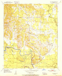
1951 Map of Ben Lomond
USGS Topo · Published 1951About this map
The Little River winds through the southwestern corner of this Arkansas landscape, defining the county line between Sevier and Little River counties. Along its banks, the settlement of White Cliffs serves as a local hub, featuring the White Cliffs School and the White Cliffs Station on the Graysonia Nashville and Ashdown railroad line. The map reveals a rural economy tied to the land and water, with numerous sloughs like Big Slough and Hickory Slough carving through the river bottomlands.
Find a feature on this map
46 named features on this map. Tap any name to fly to it.
Don’t see what you’re looking for? This feature index may not catch every label — zoom into the map to look around manually.
Map Details
Editions of this 1951 Ben Lomond Map
2 editions found
Other maps of this area

1950 · Ashdown East
USGS Topo · 1:24,000

1950 · Ashdown West
USGS Topo · 1:24,000

1950 · Red Bluff
USGS Topo · 1:24,000

1950 · Ben Lomond
USGS Topo · 1:24,000

1950 · Falls Chapel
USGS Topo · 1:24,000

1951 · Ashdown West
USGS Topo · 1:24,000

1951 · Red Bluff
USGS Topo · 1:24,000

1951 · Falls Chapel
USGS Topo · 1:24,000

1951 · Ashdown East
USGS Topo · 1:24,000

1951 · Mineral Springs South
USGS Topo · 1:24,000