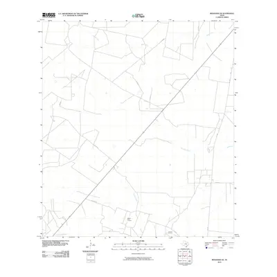
2010 Map of Benavides NE
USGS Topo · Published 2010About this map
Rosito Creek and Narciseno Creek define the drainage patterns of this South Texas landscape in Duval County. This 2010 survey illustrates a region dominated by ranching and oil and gas activity, evidenced by the network of private and county roads crisscrossing the terrain. Notable for genealogists, the map identifies small, family-associated burial grounds including the Segura-Saenz Cemetery and Longoria Cemetery, which are often the primary markers of historical settlement in this rural area. The primary transport corridors consist of Fm 1329 and a system of local routes such as Guajillo Rd and Ibene Rd that provide access to the interior brushland and various creek crossings like Guajillo Creek.
Find a feature on this map
13 named features on this map. Tap any name to fly to it.
Don’t see what you’re looking for? This feature index may not catch every label — zoom into the map to look around manually.
Map Details
Editions of this 2010 Benavides NE Map
This is the sole edition of this map. No revisions or reprints were ever made.
Other maps of this area

1917 · Ben Bolt
USGS Topo · 1:62,500

1920 · San Diego
USGS Topo · 1:62,500

1956 · Benavides
USGS Topo · 1:62,500

1956 · Rosita Ranch
USGS Topo · 1:62,500

1956 · Laredo
USGS Topo · 1:250,000

1963 · San Diego
USGS Topo · 1:24,000

1963 · Ben Bolt NW
USGS Topo · 1:24,000
1963 · Palito Blanco
USGS Topo · 1:24,000

1968 · Benavides NW
USGS Topo · 1:24,000

1968 · San Jose
USGS Topo · 1:24,000