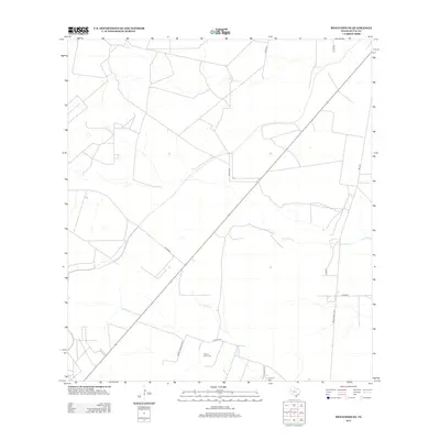
2013 Map of Benavides NE
USGS Topo · Published 2013About this map
Segura Saenz Cem and Longoria Cem stand as significant genealogical landmarks within this rural stretch of South Texas. The landscape is defined by the ephemeral drainage patterns of Rosita Cr, Narciseno Cr, and Guajillo Cr, which carve through the brush country of Duval County. This survey reveals a transition in land use and access, where modern thoroughfares like FM 1329 and Ranch Road 1329 intersect with an older network of county and ranch roads. The presence of named local routes, such as Pedro Caballero Rd and Guajillo Rd, suggests long-standing family landholdings and property boundaries in this part of the state. The map captures a primarily agricultural and ranching environment, largely unchanged in its fundamental layout into the early 21st century.
Find a feature on this map
16 named features on this map. Tap any name to fly to it.
Don’t see what you’re looking for? This feature index may not catch every label — zoom into the map to look around manually.
Map Details
Editions of this 2013 Benavides NE Map
This is the sole edition of this map. No revisions or reprints were ever made.
Other maps of this area

1917 · Ben Bolt
USGS Topo · 1:62,500

1920 · San Diego
USGS Topo · 1:62,500

1956 · Benavides
USGS Topo · 1:62,500

1956 · Rosita Ranch
USGS Topo · 1:62,500

1956 · Laredo
USGS Topo · 1:250,000

1963 · San Diego
USGS Topo · 1:24,000

1963 · Ben Bolt NW
USGS Topo · 1:24,000
1963 · Palito Blanco
USGS Topo · 1:24,000

1968 · Benavides NW
USGS Topo · 1:24,000

1968 · San Jose
USGS Topo · 1:24,000