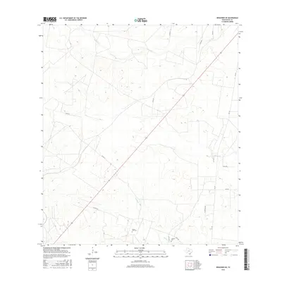
2016 Map of Benavides NE
USGS Topo · Published 2016About this map
Segura - Saenz Cem and Longoria Cem provide anchor points for family history and genealogy in this corner of Duval County. The landscape is defined by the ephemeral drainage patterns of South Texas, with the winding paths of Rosita Cr, Narciseno Cr, and Guajillo Cr cutting across the terrain. These waterways, though often dry, dictate the placement of ranch roads and historic property boundaries. The sparse road network, including Guajillo Rd and Las Brasadas Rd, connects isolated ranching operations across a landscape marked by subtle elevation changes and local drainages. The map captures the quiet, rural character of the region as documented by the U.S. Geological Survey during the mid-2010s, reflecting a balance between modern infrastructure and long-standing land divisions.
Find a feature on this map
19 named features on this map. Tap any name to fly to it.
Don’t see what you’re looking for? This feature index may not catch every label — zoom into the map to look around manually.
Map Details
Editions of this 2016 Benavides NE Map
This is the sole edition of this map. No revisions or reprints were ever made.
Other maps of this area

1917 · Ben Bolt
USGS Topo · 1:62,500

1920 · San Diego
USGS Topo · 1:62,500

1956 · Benavides
USGS Topo · 1:62,500

1956 · Rosita Ranch
USGS Topo · 1:62,500

1956 · Laredo
USGS Topo · 1:250,000

1963 · San Diego
USGS Topo · 1:24,000

1963 · Ben Bolt NW
USGS Topo · 1:24,000
1963 · Palito Blanco
USGS Topo · 1:24,000

1968 · Benavides NW
USGS Topo · 1:24,000

1968 · San Jose
USGS Topo · 1:24,000