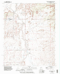
1990 Map of Benavidez Ranch
USGS Topo · Published 1996About this map
Rio Puerco defines the central axis of this high-desert landscape, cutting through a territory marked by complex jurisdictional boundaries and ranching history. The waterway is flanked by protective infrastructure, including a prominent Levee and a designated Road on Levee that facilitates movement through the river valley. To the west, the terrain rises into the Laguna Indian Reservation, while the southern reaches incorporate the Canoncito Navajo Indian Reservation. This 1990s record of Bernalillo and Sandoval counties highlights isolated ranching outposts such as Rio Puerco Ranch and Benavidez Ranch, which represent the enduring agrarian presence in a region dominated by the large land grant of the Town of Atrisco. The map reflects the intersection of tribal lands, historic grants, and the physical engineering required to manage water in the New Mexico arid lands.
Find a feature on this map
13 named features on this map. Tap any name to fly to it.
Don’t see what you’re looking for? This feature index may not catch every label — zoom into the map to look around manually.
Map Details
Editions of this 1990 Benavidez Ranch Map
This is the sole edition of this map. No revisions or reprints were ever made.
Other maps of this area

1883 · Mt. Taylor
USGS Topo · 1:250,000

1886 · Mt. Taylor
USGS Topo · 1:250,000

1888 · Bernalillo
USGS Topo · 1:125,000

1889 · Albuquerque
USGS Topo · 1:125,000

1892 · Mt. Taylor
USGS Topo · 1:250,000

1893 · Albuquerque
USGS Topo · 1:125,000

1899 · Mt. Taylor
USGS Topo · 1:250,000

1954 · Herrera
USGS Topo · 1:24,000

1954 · Volcano Ranch
USGS Topo · 1:24,000

1954 · Sky Village
USGS Topo · 1:24,000