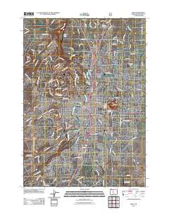
2011 Map of Bend
USGS Topo · Published 2011About this map
The Deschutes River serves as the central artery for Bend in the early 21st century, its waters managed by infrastructure like the North Unit Diversion Dam and the Bend Power Dam. This map reveals a community defined by its volcanic topography, where residential and commercial growth navigate the steep rises of Awbrey Butte, Overturf Butte, and the prominent Pilot Butte. The intricate network of irrigation, including the Tumalo Feed Canal and Bend Feed Canal, speaks to the region's managed water history, while various small aviation sites like the Gopher Gulch Airstrip and Pilot Butte Airport dot the landscape. Local history is anchored by long-standing landmarks such as the Greenwood Cemetery and the industrial presence of the Bend Seed Extractory, illustrating a landscape where modern development and natural landforms converge.
Find a feature on this map
120 named features on this map. Tap any name to fly to it.
Don’t see what you’re looking for? This feature index may not catch every label — zoom into the map to look around manually.
Map Details
Editions of this 2011 Bend Map
This is the sole edition of this map. No revisions or reprints were ever made.
Other maps of this area

1926 · Bend
USGS Topo · 1:125,000

1929 · Bend
USGS Topo · 1:125,000

1931 · Newberry Crater
USGS Topo · 1:125,000

1935 · Newberry Crater
USGS Topo · 1:125,000

1955 · Crescent
USGS Topo · 1:250,000

1955 · Bend
USGS Topo · 1:250,000

1957 · Crescent
USGS Topo · 1:250,000

1957 · Bend
USGS Topo · 1:250,000

1958 · Crescent
USGS Topo · 1:250,000

1958 · Bend
USGS Topo · 1:250,000