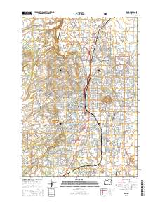
2014 Map of Bend
USGS Topo · Published 2014About this map
The city of Bend sits at the heart of this central Oregon landscape, defined by a complex network of volcanic topography and vital irrigation waterways. Prominent cinder cones like Awbrey Butte, Pilot Butte, and Overturf Butte rise directly out of the urban and suburban grid, providing distinct landmarks that shape the local geography. The Deschutes River winds through the southwestern portion of the sheet, while the Bnsf railroad line cuts through the city center, marking the historic transportation corridor.
Find a feature on this map
221 named features on this map. Tap any name to fly to it.
Don’t see what you’re looking for? This feature index may not catch every label — zoom into the map to look around manually.
Map Details
Editions of this 2014 Bend Map
This is the sole edition of this map. No revisions or reprints were ever made.
Other maps of this area

1926 · Bend
USGS Topo · 1:125,000

1929 · Bend
USGS Topo · 1:125,000

1931 · Newberry Crater
USGS Topo · 1:125,000

1935 · Newberry Crater
USGS Topo · 1:125,000

1955 · Crescent
USGS Topo · 1:250,000

1955 · Bend
USGS Topo · 1:250,000

1957 · Crescent
USGS Topo · 1:250,000

1957 · Bend
USGS Topo · 1:250,000

1958 · Crescent
USGS Topo · 1:250,000

1958 · Bend
USGS Topo · 1:250,000