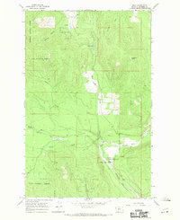
1966 Map of Bend
USGS Topo · Published 1970About this map
The Thompson River winds through the southern reaches of this mountainous region, forming a prominent horseshoe bend that gives the area its name. This mid-1960s landscape is largely defined by the convergence of the Lolo National Forest and Kootenai National Forest, where steep timbered slopes are cut by numerous drainage systems. Significant landmarks include the Bend Work Center and the adjacent Bend Campground, which serve as the primary human footprint in a territory otherwise dominated by natural features like Skookum Point. The map captures a detailed hydrological network, from the high Twin Lakes to the smaller Whitney Springs and Boiling Springs, illustrating how the high-country water feeds the river system. The presence of private access roads winding along the riverbanks suggests the intersection of public forest management and localized timber or recreational land use during this era.
Find a feature on this map
20 named features on this map. Tap any name to fly to it.
Don’t see what you’re looking for? This feature index may not catch every label — zoom into the map to look around manually.
Map Details
Editions of this 1966 Bend Map
This is the sole edition of this map. No revisions or reprints were ever made.
Other maps of this area

1920 · Jennings
USGS Topo · 1:125,000

1935 · Thompson Lakes
USGS Topo · 1:96,000

1937 · Thompson Falls
USGS Topo · 1:125,000

1942 · Thompson Lakes
USGS Topo · 1:125,000

1956 · Wallace
USGS Topo · 1:250,000

1957 · Kalispell
USGS Topo · 1:250,000

1960 · Kalispell
USGS Topo · 1:250,000

1960 · Wallace
USGS Topo · 1:250,000

1961 · Kalispell
USGS Topo · 1:250,000

1964 · Meadow Peak
USGS Topo · 1:24,000