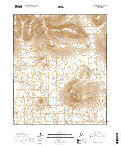
2017 Map of Bendeleben A-5 SW
USGS Topo · Published 2017About this map
Libby River and its intricate tributaries dominate this section of the Seward Peninsula, revealing a complex drainage system within the Nome Census Area. The topography is defined by the winding course of the W Fork Libby River, which meanders through a landscape of varying elevations and small ponds. These watercourses were historically significant for local travel and prospecting in the region north of Solomon. Smaller drainages like American Cr in the southeast and Sherrette Cr in the southwest further illustrate the hydrologic character of the terrain. The survey clearly delineates the township and range boundaries, including t5s r28w and t5s r29w, providing a precise grid for land navigation and historical claims research in this remote Alaskan interior.
Find a feature on this map
10 named features on this map. Tap any name to fly to it.
Don’t see what you’re looking for? This feature index may not catch every label — zoom into the map to look around manually.
Map Details
Editions of this 2017 Bendeleben A-5 SW Map
This is the sole edition of this map. No revisions or reprints were ever made.
Other maps of this area

1907 · Casadepaga
USGS Topo · 1:62,500

1950 · Bendeleben A-6
USGS Topo · 1:63,360

1950 · Bendeleben A-5
USGS Topo · 1:63,360

1950 · Bendeleben
USGS Topo · 1:250,000

1950 · Solomon
USGS Topo · 1:250,000

1950 · Solomon D-6
USGS Topo · 1:63,360

1950 · Solomon D-5
USGS Topo · 1:63,360

1951 · Bendeleben
USGS Topo · 1:250,000

1951 · Solomon
USGS Topo · 1:250,000

1964 · Bendeleben
USGS Topo · 1:250,000