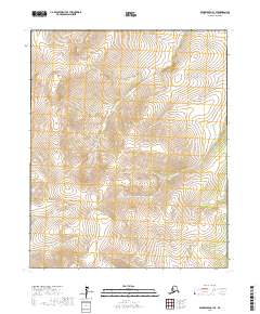
2017 Map of Bendeleben C-1 SE
USGS Topo · Published 2017About this map
The Continental Divide defines the hydrological spine of this high-latitude landscape, where the waters of the Northwest Arctic begin their journey toward opposing coasts. This 2017 survey shows a terrain dominated by significant peaks such as Kiwalik Mtn in the south and Monument Mtn in the northwest, punctuating a complex network of drainage basins. The map captures an era of untouched wilderness, where the naming of waterways like Gold Run and First Chance Cr hints at the prospecting history of the Seward Peninsula region.
Find a feature on this map
17 named features on this map. Tap any name to fly to it.
Don’t see what you’re looking for? This feature index may not catch every label — zoom into the map to look around manually.
Map Details
Editions of this 2017 Bendeleben C-1 SE Map
This is the sole edition of this map. No revisions or reprints were ever made.
Other maps of this area

1950 · Bendeleben C-1
USGS Topo · 1:63,360

1950 · Bendeleben B-1
USGS Topo · 1:63,360

1950 · Bendeleben
USGS Topo · 1:250,000

1950 · Candle B-6
USGS Topo · 1:63,360

1950 · Candle C-6
USGS Topo · 1:63,360

1951 · Candle
USGS Topo · 1:250,000

1951 · Bendeleben
USGS Topo · 1:250,000

1955 · Candle
USGS Topo · 1:250,000

1964 · Bendeleben
USGS Topo · 1:250,000

1964 · Candle
USGS Topo · 1:250,000