
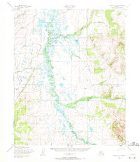
1950 Map of Candle C-6
USGS Topo · Published 1956About this map
The Kiwalik River winds through a vast network of marshes and oxbows in this mid-century survey of the Seward Peninsula’s interior. Mapped by the Army Map Service using aerial photography from the late 1940s, the terrain is defined by a sparse but vital transport network, including the Winter Trail and several stretches of Tractor Trail that provided access to remote drainages. Gold mining history is etched into the landscape through the names of various tributaries, such as Bonanza Creek, Gold Creek, and Eldorado Creek, which suggest the prospecting activity that shaped this region. To the east, the topography rises sharply toward high ridges cut by Hunter Creek and Quartz Creek, illustrating the sharp transition from the river valley’s wetlands to the more mountainous upland interior of the Northwest Arctic.
Find a feature on this map
13 named features on this map. Tap any name to fly to it.
Don’t see what you’re looking for? This feature index may not catch every label — zoom into the map to look around manually.
Map Details
Editions of this 1950 Candle C-6 Map
2 editions found
Other maps of this area

1950 · Bendeleben C-1
USGS Topo · 1:63,360

1950 · Bendeleben B-1
USGS Topo · 1:63,360

1950 · Bendeleben
USGS Topo · 1:250,000

1950 · Candle C-5
USGS Topo · 1:63,360

1950 · Bendeleben D-1
USGS Topo · 1:63,360

1950 · Candle B-5
USGS Topo · 1:63,360

1950 · Candle B-6
USGS Topo · 1:63,360

1951 · Candle
USGS Topo · 1:250,000

1951 · Bendeleben
USGS Topo · 1:250,000

1951 · Candle D-5
USGS Topo · 1:63,360