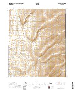
2017 Map of Bendeleben C-1 SW
USGS Topo · Published 2017About this map
Independence Cr and Quartz Cr define the drainage patterns of this Arctic landscape in the Bendeleben region. The map captures a transition of unnamed high-latitude terrain where numerous small waterways, including Dominion Cr and Theresa Cr, carve through the Seward Peninsula interior. This 2017 survey details the complex network of creeks that feed into larger regional basins, illustrating the seasonal hydrology of the Northwest Arctic Borough.
Find a feature on this map
15 named features on this map. Tap any name to fly to it.
Don’t see what you’re looking for? This feature index may not catch every label — zoom into the map to look around manually.
Map Details
Editions of this 2017 Bendeleben C-1 SW Map
This is the sole edition of this map. No revisions or reprints were ever made.
Other maps of this area

1950 · Bendeleben C-1
USGS Topo · 1:63,360

1950 · Bendeleben B-2
USGS Topo · 1:63,360

1950 · Bendeleben C-2
USGS Topo · 1:63,360

1950 · Bendeleben B-1
USGS Topo · 1:63,360

1950 · Bendeleben
USGS Topo · 1:250,000

1951 · Bendeleben
USGS Topo · 1:250,000

1964 · Bendeleben
USGS Topo · 1:250,000
2014 · Bendeleben C-1 NE
USGS Topo · 1:25,000
2017 · Bendeleben C-2 SE
USGS Topo · 1:25,000
2017 · Bendeleben C-1 NW
USGS Topo · 1:25,000