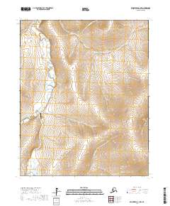
2017 Map of Bendeleben C-1 NW
USGS Topo · Published 2017About this map
Independence Creek Airport serves as a lone human waypoint in this high-latitude drainage basin on the Seward Peninsula. The landscape is dominated by the meandering Kugruk River, which flows through the western portion of the quadrangle, joined by tributaries such as Holtz Cr and Independence Cr. The terrain is characterized by a series of north-south ridges and narrow creek valleys, including Mina Cr and Champion Cr to the north, and Dominion Cr and Eldorado Cr in the southeast. This 2017 survey illustrates the remote aviation infrastructure necessary for access to the Northwest Arctic, where the drainage patterns of these named creeks dictate the movement across the tundra and provide the primary landmarks for navigation in the absence of a road network.
Find a feature on this map
13 named features on this map. Tap any name to fly to it.
Don’t see what you’re looking for? This feature index may not catch every label — zoom into the map to look around manually.
Map Details
Editions of this 2017 Bendeleben C-1 NW Map
This is the sole edition of this map. No revisions or reprints were ever made.
Other maps of this area

1950 · Bendeleben C-1
USGS Topo · 1:63,360

1950 · Bendeleben C-2
USGS Topo · 1:63,360

1950 · Bendeleben D-2
USGS Topo · 1:63,360

1950 · Bendeleben
USGS Topo · 1:250,000

1950 · Bendeleben D-1
USGS Topo · 1:63,360

1951 · Bendeleben
USGS Topo · 1:250,000

1964 · Bendeleben
USGS Topo · 1:250,000
2014 · Bendeleben D-1 SE
USGS Topo · 1:25,000
2014 · Bendeleben C-1 NE
USGS Topo · 1:25,000
2017 · Bendeleben C-2 SE
USGS Topo · 1:25,000