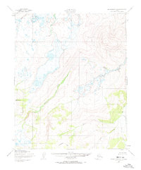
1950 Map of Bendeleben C-2
USGS Topo · Published 1973About this map
The Continental Divide traverses the southern portion of this landscape, marking a significant hydrologic boundary in the Seward Peninsula interior. This region is defined by the winding course of the Kugruk River, which flows through a network of drainage basins including Circle Creek and Spruce Creek. A notable man-made feature is the Fairhaven Ditch, a major hydraulic engineering project designed to carry water for gold mining operations during the early twentieth century. Evidence of human activity is sparse but present, noted by Cabins situated near the headwaters of the Burnt River. The map illustrates the specialized infrastructure required for Arctic mining, showing how the ditch system follows the contours of the land to reach distant claims near landmarks like Kettle Dome.
Find a feature on this map
11 named features on this map. Tap any name to fly to it.
Don’t see what you’re looking for? This feature index may not catch every label — zoom into the map to look around manually.
Map Details
Editions of this 1950 Bendeleben C-2 Map
3 editions found
Other maps of this area

1950 · Bendeleben C-1
USGS Topo · 1:63,360

1950 · Bendeleben C-3
USGS Topo · 1:63,360

1950 · Bendeleben B-2
USGS Topo · 1:63,360

1950 · Bendeleben C-2
USGS Topo · 1:63,360

1950 · Bendeleben B-1
USGS Topo · 1:63,360

1950 · Bendeleben B-3
USGS Topo · 1:63,360

1950 · Bendeleben D-2
USGS Topo · 1:63,360

1950 · Bendeleben
USGS Topo · 1:250,000

1950 · Bendeleben D-3
USGS Topo · 1:63,360

1950 · Bendeleben D-1
USGS Topo · 1:63,360