
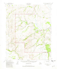
1950 Map of Bendeleben D-3
USGS Topo · Published 1956About this map
The Inmachuk River and Pinnell River systems dominate this mid-century topographic record of the Seward Peninsula, captured during a 1949-1950 aerial survey. The landscape reflects a history of high-latitude resource extraction, evidenced by a Gold Mine situated near Hannum Creek and the presence of a Tractor Trail cutting through the northern reaches. These industrial markings appear alongside significant natural landmarks like the prominent Asses Ears Mountain and the distinct volcanic profiles of Crossfox Butte and Twincairn Cone.
Find a feature on this map
33 named features on this map. Tap any name to fly to it.
Don’t see what you’re looking for? This feature index may not catch every label — zoom into the map to look around manually.
Map Details
Editions of this 1950 Bendeleben D-3 Map
2 editions found
Other maps of this area

1950 · Bendeleben C-3
USGS Topo · 1:63,360

1950 · Bendeleben C-2
USGS Topo · 1:63,360

1950 · Bendeleben C-4
USGS Topo · 1:63,360

1950 · Bendeleben D-2
USGS Topo · 1:63,360

1950 · Bendeleben
USGS Topo · 1:250,000

1950 · Bendeleben D-4
USGS Topo · 1:63,360

1950 · Kotzebue A-4
USGS Topo · 1:63,360

1950 · Kotzebue A-3
USGS Topo · 1:63,360

1950 · Kotzebue A-2
USGS Topo · 1:63,360

1951 · Bendeleben
USGS Topo · 1:250,000