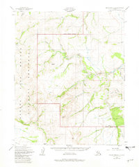
1950 Map of Bendeleben D-3
USGS Topo · Published 1982About this map
Bering Land Bridge National Preserve dominates this Arctic landscape, where the interior Seward Peninsula meets a network of vital waterways. The Inmachuk River and Pinnell River carve through the terrain, historically serving as key corridors for movement and mineral exploration. The presence of the Fairhaven Ditch in the southeastern corner highlights early 20th-century hydraulic mining efforts, a massive engineering feat designed to carry water to gold-bearing gravels. Evidence of bush aviation and remote travel is visible at the Upper Hannum Creek Airport and along the rugged TRACTOR Hannum Trail. Prominent geological landmarks such as Crossfox Butte and Twincairn Cone provided essential navigation points for travelers moving between the drainage of Snow Gulch and the settlement at Fink Creek.
Find a feature on this map
37 named features on this map. Tap any name to fly to it.
Don’t see what you’re looking for? This feature index may not catch every label — zoom into the map to look around manually.
Map Details
Editions of this 1950 Bendeleben D-3 Map
2 editions found
Other maps of this area

1950 · Bendeleben C-3
USGS Topo · 1:63,360

1950 · Bendeleben C-2
USGS Topo · 1:63,360

1950 · Bendeleben C-4
USGS Topo · 1:63,360

1950 · Bendeleben D-2
USGS Topo · 1:63,360

1950 · Bendeleben
USGS Topo · 1:250,000

1950 · Bendeleben D-3
USGS Topo · 1:63,360

1950 · Bendeleben D-4
USGS Topo · 1:63,360

1950 · Kotzebue A-4
USGS Topo · 1:63,360

1950 · Kotzebue A-3
USGS Topo · 1:63,360

1950 · Kotzebue A-2
USGS Topo · 1:63,360