
1950 Map of Kotzebue A-3
USGS Topo · Published 1957About this map
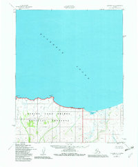
Kotzebue Sound dominates the northern expanse of this 1950 coastal survey, where the waters meet a shoreline defined by prominent bluffs and drainage systems. The coastline is marked by distinct geographical points such as Clifford Pt and Rex Pt, where the Army Map Service utilized triangulation stations for precise elevation data. The interior terrain rises toward North Bluff, carved by a network of seasonal waterways including Clifford Creek, Rex Creek, and Mystic Creek. Further east, the landscape transitions at the Sullivan Bluffs, which overlook the brackish environment surrounding Sullivan Lake and its outflow, Sullivan Creek. This chart records the coastal topography of Northwest Alaska before the introduction of modern infrastructure, showing a wilderness area defined solely by its natural landmarks and survey benchmarks.
Find a feature on this map
12 named features on this map. Tap any name to fly to it.
Don’t see what you’re looking for? This feature index may not catch every label — zoom into the map to look around manually.
Map Details
Editions of this 1950 Kotzebue A-3 Map
2 editions found
Other maps of this area

1950 · Bendeleben D-2
USGS Topo · 1:63,360

1950 · Bendeleben
USGS Topo · 1:250,000

1950 · Bendeleben D-3
USGS Topo · 1:63,360

1950 · Bendeleben D-4
USGS Topo · 1:63,360

1950 · Kotzebue B-4
USGS Topo · 1:63,360

1950 · Kotzebue A-4
USGS Topo · 1:63,360

1950 · Kotzebue A-2
USGS Topo · 1:63,360

1951 · Bendeleben
USGS Topo · 1:250,000

1951 · Kotzebue
USGS Topo · 1:250,000

1958 · Kotzebue
USGS Topo · 1:250,000