
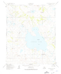
1950 Map of Bendeleben C-3
USGS Topo · Published 1955About this map
Imuruk Lake dominates this mid-century topographic study of the Seward Peninsula, its expansive waters fed by the Pinnell River and Cottonwood Creek. The landscape is defined by its volcanic history, evidenced by a series of prominent formations like Kettle Dome, Cassiope Cone, and Rhododendron Cone, which rise above significant fields of Lava. Of particular interest to industrial historians is the Fairhaven Ditch, a remarkable water conveyance system visible cutting across the terrain toward the Kugruk River. This engineering feat supported the region's hydraulic mining operations. Notable landmarks such as Skeleton Butte and the curiously named Asses Ears provide distinct navigation points across the north, while Salix Bay and Granite Bay indent the eastern shoreline of the lake.
Find a feature on this map
21 named features on this map. Tap any name to fly to it.
Don’t see what you’re looking for? This feature index may not catch every label — zoom into the map to look around manually.
Map Details
Editions of this 1950 Bendeleben C-3 Map
2 editions found
Other maps of this area

1950 · Bendeleben B-2
USGS Topo · 1:63,360

1950 · Bendeleben C-2
USGS Topo · 1:63,360

1950 · Bendeleben B-4
USGS Topo · 1:63,360

1950 · Bendeleben C-4
USGS Topo · 1:63,360

1950 · Bendeleben B-3
USGS Topo · 1:63,360

1950 · Bendeleben D-2
USGS Topo · 1:63,360

1950 · Bendeleben
USGS Topo · 1:250,000

1950 · Bendeleben D-3
USGS Topo · 1:63,360

1950 · Bendeleben D-4
USGS Topo · 1:63,360

1951 · Bendeleben
USGS Topo · 1:250,000