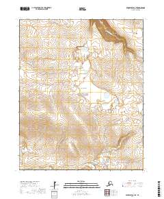
2017 Map of Bendeleben C-4 NE
USGS Topo · Published 2017About this map
The Continental Divide winds across this portion of the Seward Peninsula, marking a significant hydrological boundary within the Bering Land Bridge National Preserve. The landscape is defined by the headwaters of several major drainage systems, including the northward-flowing Goodhope River and the southward-bound Noxapaga River. This high-latitude terrain is characterized by complex drainage patterns where Esperanza Cr and Berry Cr intersect the divide's western slopes. Near the center of the sheet, Largo Ridge provides a prominent elevation marker above the surrounding tundra, situated between the valleys of Largo Cr and Carex Cr. The map illustrates a largely roadless interior, emphasizing the natural topography and the preservation of the ancestral landscape within the National Preserve boundaries.
Find a feature on this map
14 named features on this map. Tap any name to fly to it.
Don’t see what you’re looking for? This feature index may not catch every label — zoom into the map to look around manually.
Map Details
Editions of this 2017 Bendeleben C-4 NE Map
This is the sole edition of this map. No revisions or reprints were ever made.
Other maps of this area

1950 · Bendeleben C-3
USGS Topo · 1:63,360

1950 · Bendeleben C-4
USGS Topo · 1:63,360

1950 · Bendeleben
USGS Topo · 1:250,000

1950 · Bendeleben D-3
USGS Topo · 1:63,360

1950 · Bendeleben D-4
USGS Topo · 1:63,360

1951 · Bendeleben
USGS Topo · 1:250,000

1964 · Bendeleben
USGS Topo · 1:250,000
2017 · Bendeleben D-3 SW
USGS Topo · 1:25,000
2017 · Bendeleben C-3 SW
USGS Topo · 1:25,000
2017 · Bendeleben C-4 SW
USGS Topo · 1:25,000