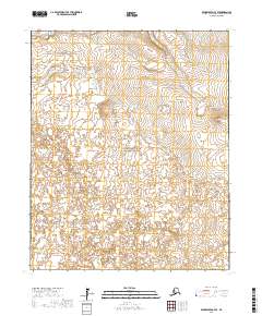
2017 Map of Bendeleben C-4 SE
USGS Topo · Published 2017About this map
The Bering Land Bridge National Preserve encompasses a large portion of this area on the Seward Peninsula, protecting a landscape that serves as a vital link to the prehistoric migration between continents. The terrain is defined by volcanic features and low-lying drainage systems, most notably the distinct heights of Dryas Cone and Andromeda Cone. These cones rise above the surrounding tundra, providing rare vertical markers in a region dominated by the winding paths of the Noxapaga River and Muskellunge Cr. The mapping reflects the isolation of the Northwest Arctic, where the absence of roads or permanent settlements highlights the wilderness character of the preserve. For researchers and geologists, the placement of these volcanic landforms against the hydrologic network offers a clear view of the geologic and environmental forces shaping this part of northern Alaska.
Find a feature on this map
12 named features on this map. Tap any name to fly to it.
Don’t see what you’re looking for? This feature index may not catch every label — zoom into the map to look around manually.
Map Details
Editions of this 2017 Bendeleben C-4 SE Map
This is the sole edition of this map. No revisions or reprints were ever made.
Other maps of this area

1950 · Bendeleben C-3
USGS Topo · 1:63,360

1950 · Bendeleben B-4
USGS Topo · 1:63,360

1950 · Bendeleben C-4
USGS Topo · 1:63,360

1950 · Bendeleben B-3
USGS Topo · 1:63,360

1950 · Bendeleben
USGS Topo · 1:250,000

1951 · Bendeleben
USGS Topo · 1:250,000

1964 · Bendeleben
USGS Topo · 1:250,000
2017 · Bendeleben C-3 SW
USGS Topo · 1:25,000
2017 · Bendeleben B-4 NE
USGS Topo · 1:25,000
2017 · Bendeleben C-4 NE
USGS Topo · 1:25,000