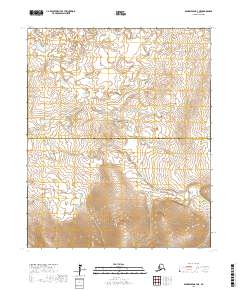
2017 Map of Bendeleben B-4 NE
USGS Topo · Published 2017About this map
The Seward Peninsula interior is defined by a landscape of vast watersheds and protected wilderness, captured here before modern shifts in northern land management. This portion of the Bering Land Bridge National Preserve contains the winding headwaters of the South Fork Kuzitrin River, also labeled in parts as the S Fork Kuzitrin River. The terrain is characterized by complex contouring that reveals the drainage patterns of the Seward highlands, where unnamed tributaries feed into the larger river system. A significant administrative division is marked by the Northwest Arctic Borough Nome Census Area boundary, which bisects the map and underscores the remote nature of this arctic region. The absence of roads or permanent structures highlighted in this 2017 survey emphasizes the area's role as a preserved corridor for migratory patterns and geological study.
Find a feature on this map
9 named features on this map. Tap any name to fly to it.
Don’t see what you’re looking for? This feature index may not catch every label — zoom into the map to look around manually.
Map Details
Editions of this 2017 Bendeleben B-4 NE Map
This is the sole edition of this map. No revisions or reprints were ever made.
Other maps of this area

1950 · Bendeleben C-3
USGS Topo · 1:63,360

1950 · Bendeleben B-4
USGS Topo · 1:63,360

1950 · Bendeleben C-4
USGS Topo · 1:63,360

1950 · Bendeleben B-3
USGS Topo · 1:63,360

1950 · Bendeleben
USGS Topo · 1:250,000

1951 · Bendeleben
USGS Topo · 1:250,000

1964 · Bendeleben
USGS Topo · 1:250,000
2017 · Bendeleben C-3 SW
USGS Topo · 1:25,000
2017 · Bendeleben B-4 SW
USGS Topo · 1:25,000
2017 · Bendeleben B-4 SE
USGS Topo · 1:25,000