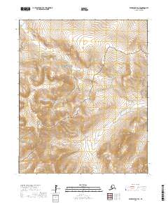
2017 Map of Bendeleben B-4 SE
USGS Topo · Published 2017About this map
The Bering Land Bridge National Preserve dominates the northern reaches of this portion of the Seward Peninsula, protecting a vast expanse of arctic tundra and volcanic terrain. In the southwestern corner, the dramatic elevation changes of the Bendeleben Mountains descend into a network of river valleys that define the local drainage patterns. These waterways, including the headwaters of the Pargon River and the winding course of Boston Cr, show the intricate hydrological systems of the Alaska interior. The map reveals a landscape largely devoid of permanent human infrastructure, instead highlighting the natural transitions between alpine heights and riparian corridors like Minnie Cr. This survey is a detailed record of land management boundaries within the Nome Census Area, where conservation lands meet the high peaks of the Bendeleben range.
Find a feature on this map
12 named features on this map. Tap any name to fly to it.
Don’t see what you’re looking for? This feature index may not catch every label — zoom into the map to look around manually.
Map Details
Editions of this 2017 Bendeleben B-4 SE Map
This is the sole edition of this map. No revisions or reprints were ever made.
Other maps of this area

1950 · Bendeleben A-4
USGS Topo · 1:63,360

1950 · Bendeleben A-3
USGS Topo · 1:63,360

1950 · Bendeleben B-4
USGS Topo · 1:63,360

1950 · Bendeleben B-3
USGS Topo · 1:63,360

1950 · Bendeleben
USGS Topo · 1:250,000

1951 · Bendeleben
USGS Topo · 1:250,000

1964 · Bendeleben
USGS Topo · 1:250,000

1970 · Bendeleben A-4
USGS Topo · 1:63,360
2017 · Bendeleben A-4 NE
USGS Topo · 1:25,000
2017 · Bendeleben B-4 NE
USGS Topo · 1:25,000