
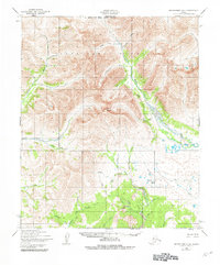
1950 Map of Bendeleben A-4
USGS Topo · Published 1955About this map
The Bendeleben Mountains dominate this 1950 interior landscape of the Seward Peninsula, a region defined by complex drainage patterns and high alpine terrain. The Niukluk River and Pargon River serve as the primary arterial waterways, fed by a dense network of gold-bearing drainages like Goldbottom Creek, Ophir Creek, and Virginia Cr. This era of the territory's history is reflected in the thin infrastructure, notably a Tractor Trail that follows the contours of Crooked Cr and the Utica Ck valley, providing a vital link for mining exploration and overland travel.
Find a feature on this map
31 named features on this map. Tap any name to fly to it.
Don’t see what you’re looking for? This feature index may not catch every label — zoom into the map to look around manually.
Map Details
Editions of this 1950 Bendeleben A-4 Map
2 editions found
Other maps of this area

1907 · Casadepaga
USGS Topo · 1:62,500

1950 · Bendeleben B-5
USGS Topo · 1:63,360

1950 · Bendeleben A-5
USGS Topo · 1:63,360

1950 · Bendeleben A-3
USGS Topo · 1:63,360

1950 · Bendeleben B-4
USGS Topo · 1:63,360

1950 · Bendeleben B-3
USGS Topo · 1:63,360

1950 · Bendeleben
USGS Topo · 1:250,000

1950 · Solomon D-3
USGS Topo · 1:63,360

1950 · Solomon
USGS Topo · 1:250,000

1950 · Solomon D-4
USGS Topo · 1:63,360