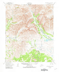
1950 Map of Bendeleben A-4
USGS Topo · Published 1982About this map
The Bendeleben Mountains dominate this 1950s landscape, where the northern portion of the quadrangle is now protected as part of the Bering Land Bridge National Preserve. The map reveals a remote environment structured by its waterways, most notably the Pargon River and its numerous tributaries such as Dillon Creek and Slab Creek. A solitary Cabin located along McKelveys Creek serves as one of the few signs of permanent human habitation in this subarctic terrain.
Find a feature on this map
36 named features on this map. Tap any name to fly to it.
Don’t see what you’re looking for? This feature index may not catch every label — zoom into the map to look around manually.
Map Details
Editions of this 1950 Bendeleben A-4 Map
2 editions found
Other maps of this area

1907 · Casadepaga
USGS Topo · 1:62,500

1950 · Bendeleben B-5
USGS Topo · 1:63,360

1950 · Bendeleben A-4
USGS Topo · 1:63,360

1950 · Bendeleben A-5
USGS Topo · 1:63,360

1950 · Bendeleben A-3
USGS Topo · 1:63,360

1950 · Bendeleben B-4
USGS Topo · 1:63,360

1950 · Bendeleben B-3
USGS Topo · 1:63,360

1950 · Bendeleben
USGS Topo · 1:250,000

1950 · Solomon D-3
USGS Topo · 1:63,360

1950 · Solomon
USGS Topo · 1:250,000